
Latsch to Samedan
STATS
DATE
9.8.2019 - 16.8.2019
ROUTE
Latsch - Tschingels - Stilfserjoch - Bochetta di Forcola - Santa Caterina - Passo del Alpe - Sondalo - Passo della Forcola - Eita - Passo Dosdè - Passo di Val Viola - Passo di Val Mera - La Stretta - Fuorcla Grischa - Samedan
DISTANCE/ELEVATION GAIN
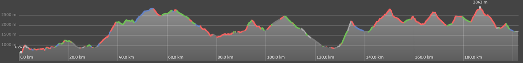
202KM / 11200M
DURATION
8 days
TYPE
multiday tramping
DIFFICULTY
T2-T3
ALTITUDE CHART
PHOTOS


REPORT
INTRO
When I was visiting my South Tyrolean friends Gisella and Klaus in Latsch last spring, they mentionned a hike around the mountain Ortler, which they were planning on doing this summer. The special touch: For the hike, they'd invite hikers, who they'd met while hiking Te Araroa.
This intriguing idea instantly caught my interest and thus I decided to try my best to get a few days off to be able to join them on their little adventure.
Luckily none of my working colleagues have applied for holiday during that time frame yet, which enables me to squeeze in some off-days.
Still, I only manage to get 9 days off. While it's not enough to complete the whole 10-day-round-the-mountain-hike, at least I would be able join them for a few days, before I will hike my own hike, which would take me over several passes back to Samedan.
While it certainly is a pity I wont be able to join them for their whole hike, I actually don't mind hiking the remaining days alone. Because that's what I was on Te Araroa and probably always will be: A solo hiker. Suits me best I guess. Nonetheless, I'm very excited to meet all the Te Araroa alumni!
As the starting date for the hike approaches, the list of the participants is materializing. Besides Gisella, Klaus and me, Christian a fellow Swiss, Sarah and Jay from Germany, the Kiwi Ruslan aswell as Hilde, another South Tyrolean will form our hiking group. 8 hikers, which I'm really looking forward to meeting.
The first one I meet is Christian, he kindly offers me a ride from Zernez to Latsch. Saves me a bit of time and money. After a very scenic drive through the Swiss National Park, we arrive in Latsch during the late afternoon. Gisella and Ruslan are already awaiting us. Klaus, Sarah and Jay arrive a few minutes later. In Klaus and Gisella's wonderful home we spend a lovely evening together, exchanging stories, getting to know each other. I carb-load my body with a delicious South Tyrolean cold platter and even more amazing Marillenknödel. With my belly full to its bursting point, I'm now fully ready for the first day tomorrow. So exciting!
DAY 1 - Living like kings
Distance: 27km
Elevation Gain: 1300m
It's a lazy start into our first day. That's exactly the way it should be.
After a heartily breakfast and some final 'before the hike' photos, we set off, Klaus as our personal guide leading the way. The hike starts with a sweet climb, which takes us a few hundred metres above the Vinschgau. The views of the valley, packed with apple orchards, is lovely. The pace along the undulating, wide trails is pleasant and enables me to get to know the others a bit better.
Walking on the southerly facing slopes means the sun is relentlessly shining down on us, making it fairly tough to walk at times. So I, and by observing the others as well, don't mind when we descent back down to the valley floor, where we cross the valley to Tschengls. Gisella and Klaus organized a visit of the castle with it's fascinating, unconventional thinker and lord of the castle Karl. We have a great dinner in the castle's food chamber. My personal highlight of the day. Plenty of delicious food with, most importantly lots of carbs. Can't get enough of them ;)
With a full stomach, we feel too lazy to continue to our designated camp spot, located another 30 minutes walk away and unroll our sleeping pads in the castle. Many thanks for the great hospitality!
DAY 2 - The mountains are calling
Distance: 22km
Elevation Gain: 1960m
Royally well rested we head out again. Unfortunately, Christian's pain in his feet, which resulted from a misstep the day before starting the hike, deteriorated during the night and in regards of the upcoming climbs and descents he decides to abandon the hike.
The remaining seven of us follow a gravel road to Prad. It's a muggy morning and a weather condition, which apparently appeals to horseflies. The annoying insects follow us until we reach the town on the feet of the Stilfserjoch, Europe's second highest road pass.
From Prad it's only direction: up, up, up. Up and into the mountains. Since it got cooked for us yesterday, my backpack is still uncomfortably heavy and I definitively feel it during the climb. But I'm not the only one. Also the others feel the weight of their packs. We take it slowly, taking rests when needed. This is new to me. I usually keep on pushing without stopping despite feeling exhausted. Even though I don't mind the numerous breaks, getting back into my rhythm is not easy. At Prader Alm we splurge a bit and get an Apfelstrudel. A must-eat while in the region and well needed energy for the last few kilometres of the day, which are offering spectacular views of 3900 metres high Ortler, which finally appeared from behind the clouds.
Finding a suitable camp spot with water and space for 6 tents is not as easy as it might seems. At around six we spot an area, which is one of the rare possibilities to camp. It's not perfect since the camp spots are not exactly flat but at least there's water. Should we camp or should we continue? A question frequently asked on Te Araroa as well. The little but pressing problems in a hiker's life.
We decide to play it save and stay here for the night. Once the decision was made, we all pitch our tents. Everyone very quick and slick. Lots of routine. It's obvious we all have done it many times in the past.
DAY 3 - Easy-peasy-lemon-squeezy-day
Distance: 22km
Elevation Gain: 880m
My down sloping camp spot made it not too comfortable to sleep. Needless to say. From day 1 on Te Araroa, I never slept well in a tent. The hundreds of nights I have camped since haven't changed anything. But the lack of sleep doesn't really affect me when on the trail. So no problem there.
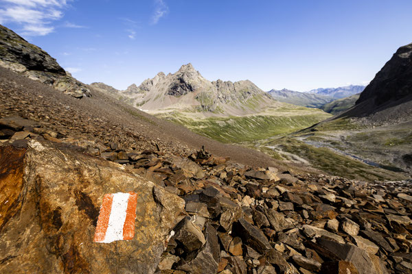
We set of at 7:30 on a foggy morning towards Stilfserjoch, on a sidling trail, nicely carved into the steep slopes. The odd snowfields are a nice change. While the trail is not particularly difficult, it takes a bit of concentration. A misstep would mean a long, deadly tumble down.
My legs are feeling great and shortly before reaching Stilfserjoch, I decide to make a small detour to climb Rötelspitz, which would have been my first 3000 metre-peak of the season. However, since it's so easily reachable from Stilfserjoch, a flock of mostly older folks is ahead of me and blocking my way. This is something that turns me off completely and I decide to abort my little mission and rejoin the others close to Stilfserjoch, right on the Swiss-Italian border. While we have a break, some Swiss e-bikers are approaching the place. And for me it's an appropriate time to start a little rant about e-bikers, since they already greatly annoyed me on the way from the campspot to Stilfserjoch. Should you be an e-biker, you might skip the following lines a you most probably won't enjoy what you are about to read...
So these e-bikers arrive, puffing like a steam locomotive. One fatter than the other, all dressed in the latest, most fashionable cycling gear. But... without their little electric helper, they wouldn't be able to cycle a single kilometre. But with the motor they can now reach places, which were unreachable before. Places where they shouldn't be in. The tricky terrain is overwhelming them and hearing stuff like 'Why is everyone complaining about the melting glaciers. Still a lot of this stuff up here' while looking at Ortler's shrinking glaciers makes me feel ashamed of my fellow Swiss countrymen.
Enough complaining for now. Back on the trail, back to the nice things in life! We have a short stint on Swiss territory, descending towards Umbrailpass. From here, it's a climb up to Bochetta di Forcola. With my legs feeling great, I dash ahead. While waiting for the others, I absorb the great landscape. Extremely wild with nothing but rocks, still, the terrain surprisingly flat. One by one the others arrive. They use the wind to dry out their tens. Funnily enough, I have never seen anyone doing it before, let alone, considered to do it myself. While I totally understand the purpose of doing it, I can't really be bothered doing it myself. Too lazy. From the pass we follow wide gravel paths down towards Bormio. A relic from the great wars. While these gravel paths certainly make walking easy, they are also a bit boring. They would be amazing for trail running. If this region wasn't so hard to reach from Samedan, I'd come back in no time. Thanks to the easy trails, we make good progress on this sunny but windy Sunday afternoon and are way ahead of schedule. Instead of getting too close to Bormio, where camping spots would most certainly be very limited, we finish early and pitch our tents on a perfectly level area. All tents close together and a river providing water for cooking and a well needed wash.
The early finish gives me time to treat my left feet. While walking in Sandals certainly bears many advantages, cracks in the skin are a big problem. Especially in the heel. Even though I try to preemptively avoid them by rasping off horny skin windy, dry, windy days like today will crack the skin nonetheless. If it happens on the trail, not much can be done, unfortunately. At least: Keeping the heels moist overnight, eases the pain. Still, I already know: the left heel will cause quite a bit of pain until I reach Samedan.
DAY 4 - Farewell and an evacuation
Distance: 36km
Elevation Gain: 1920m
Yesterday's early finish makes us leave quite early today. Perfect for me. The earlier the better. Once again I haven't slept too good. I was extremely thirsty, even had to go down to the river to refill my 1.5 liter bottle at midnight.
So I wasn't too unhappy to start the day with plenty of easy gravel road walk. Mostly down. Luckily no-one needs to resupply in Bormio, so we give the town a wide berth. Today's hike is mostly through Alpine pine forest. Very pleasant. On the soft ground I can even walk a few steps barefoot.
Today's the last day I hike together with the others. After the town of Santa Caterina our paths will split. To keep my tight schedule I have to make it past Santa Caterina, preferably up to Passo della Alpe. As the day advances, I realize I'd have to leave the group before reaching the town. Otherwise I won't make it far enough. Once it was decided to have lunch, it's the sign for me to say goodbye. Since I'm not exactly good at it, I keep it short and go my own way. Two things instantly change: Firstly, the pace is much faster, secondly I have to navigate myself. Before that, Klaus was doing all the navigating and did a great job keeping us from getting lost. A big thanks to Klaus at this point! It made my trail life a lot easier.
A rather steep climb followed by a similarly steep descent takes me to Santa Caterina. Since I still got plenty of food, I hike right through the busy town, just quickly downloading the weather forecast and maps when I discovered a free WIFI.
As it turns out, it's not easy to get from the town to Passo del'Alpe. There's a trail going the right direction but I'm not sure if it would get me there all the way. If I had to turn around it would be a helluva detour. So I decide to play it safe and follow the main road towards the turn off to my pass. Luckily the road is quiet and the views are getting greater, the higher I climb above the valley. It's a gradual, simple ascent, which gives me time to reflect the last few days. I can't talk for the others but I enjoyed them a lot. It's a different kind of hiking, for me a social event rather than focusing solely on the athletic accomplishments.
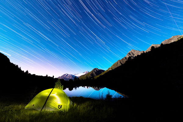
While reminiscing, dark rain clouds were approaching and are now looming over the mountain tops. Smart-ass Sandro thinks he is clever and spots a sheltered spot a few metres away and above a small creek. I pitch my tent just before the rain starts. Sounds all great, right? Well, problem is that the rain gets heavier and heavier, turning into torrential downpour. Lighting strikes all around me. Second time within two weeks I get caught in the the middle of a thunderstorm. This time though, I'm less worried about getting hit by a lighting but rather by the creek, which is turning into a river within minutes. While I'm still in a safe distance, the quickly swelling, now brown river and the danger of mudslides, make me decide to pack everything into drybags and get ready to move to higher grounds. A break in the rain is the opportunity to evacuate my not-so-perfect-anymore camping spot. Takes me roughly 5 minutes until I can crawl back into my sleeping bag, in a safe distance from the water. With the worst of the storm moving north and away from me I finally have time to relax and get some sleep, hoping the others were smarter than I in finding a good camp spot.
DAY 5 - The quiet after the storm
Distance: 35km
Elevation Gain: 1500m
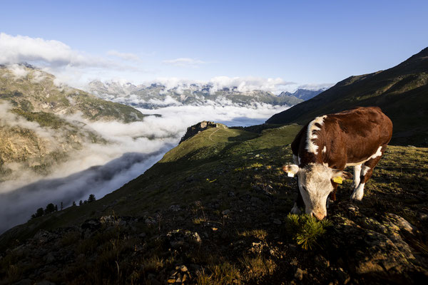
Just after 5 in the morning, I get woken up by a passing car on it's way to a nearby milking shed, which I pass a few minutes later on my way to Passo del'Alpe. It's an easy, gradual climb and the 2500 metre-high-pass fairly nondescript. So is the incredibly long descent into the Valtellina. Initially a hiking trail, my hike continues on a gravel road, passing remote Alps, where time seems to stand still. It's very interesting to observe the locals in their old Fiat's and motorcycles. The road is slowly sidling down into the valley, sometimes impressively carved into the sheer rockface. All in all a fairly nice walk. Well before noon I reach the valley floor and follow it for a few minutes to Sondalo. The only larger town I pass through and also my dedicated resupply point. Since I still have some food left, resupply is quickly completed. Still, with food for another 4 days in my pack, it's gotten noticeably heaver.
After the early start today, I'm ahead of schedule and decide to stroll around the city a bit. However, like all the other towns I've visited in the Valtellina, this one as well is rather boring. Not much to write about. The only thing that catches my attention are the massive hospitals with a huge heliport built into the slope above the city. During my lunch break, two big Agusta Helicopters land on the helipad. The highlight of my short stay in Sondalo. Yep, that's how awfully uninteresting the town is...
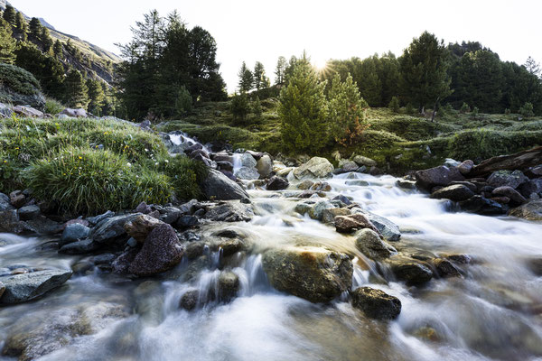
Therefore, it's not too difficult for me to leave Sondalo behind. What's more challenging is the 1400 metre-climb from Sondalo to Passo della Forcola. While initially fairly flat the trail starts climbing up steeply. They guys, who designed the track built it consistently steep, no flat part to relax my muscles. Together with my full belly and backpack it is hard work up to the pass, where I initially planned to camp. Since it's still mid-afternoon, windy and rainy, I decide to carry on, down on the other side to Eita. This side of the pass is far less steep. About halfway down to Eita I pass some baches. It's pouring down by now and I'm more than happy when an old man, who used to work in Switzerland most of his life, invites me for coffee, cookies and freshly picked, wild blueberries. What a great hospitality, which brings back memories from my time on Te Araroa.
Strengthened, I tackle the last few kilometres of the day, still not knowing where to camp. My slim hope of camping somewhere by road before reaching Eita are shattering quickly. Either trees or inhabited places make it impossible to camp. With the sky getting darker and darker, I start getting a bit nervous when, just after reaching Eita, I spot a picnic area. Soaked and tired I pitch my tent, right next to the road and some houses. No-one seems to bother too much and I'm confident I won't be disturbed by anyone during night. But to be honest, I'm too tired to care at this moment anyway.
DAY 6 - The lazy day
Distance: 20km
Elevation Gain: 1460m
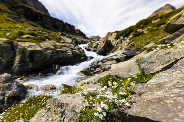
As I'm fairly certain that the campspot I've chosen last night is not meant for camping, I get up early and leave the sleepy town just after sunrise. A uncomfortably pushy horse is following me for a while until I leave the road and head up towards Passo Dosdè. It's a very pretty climb, past several lakes. The higher I get, the wilder and rockier the landscape. Also the poorly marked trail gets rougher the closer I get to the pass, which is not in sight yet though. After skirting around Lago Negro I can finally spot the shelter located on the pass, high above me. The climb up there is initially steep. At one point I loose the trail completely, which is not a big problem, since there's only one way to go anyway: Up! From time to time I use my hands to scramble up rocks. A welcome change. Eventually I rejoin the trail, which was on my left, and follow it over a rock field up to the pass. It's actually not a visible trail but rather hopping from one small rock to the next. It's slow going and a bit like walking over a minefield. Not difficult but a misstep on the spiky rocks with my sandals would result in some serious leg injuries.
Luckily all goes well and mid-morning I reach the hut. Thanks to my early start, I've got plenty of time to enjoy the spectacular views of the rugged terrain. Once I've seen enough, I descend on the other side into a totally different landscape. Less steep, more gentle but equally beautiful, Val Viola attracts heaps of people. Especially a restaurant close to Passo di Val Viola seems to attract tourists (I would not call them hikers) in droves. Apparently, it is rumored, they serve delicious polenta. I give it a wide berth nonetheless, avoiding the restaurant and the trail leading to it. Fortunately! SInce I keep left of the valley, I cross back into Switzerland not via the main trail over Passo di Val Viola but on a narrow trail over a side pass. That trail leads towards Lagh Viola, a tarn, which is my planned camp spot for the night. Planned... until I spot a lovely, green and blue shimmering tarn called Lagh dal Dügüral far below the trail. That's it, my camping spot for the night. Not often but sometimes it happens: You see that place that is simply perfect to camp. Without thinking too much, I leave the trail and steeply descend to the lake. Not easy but the effort is well worth it. A flat, grassy spot, overlooking the tarn, with the mighty Piz Palü in the background. Even though It's only 3pm, I decide to call it a day. I pitch my tent, take out my book and enjoy the indescribable landscape.
DAY 7 - Up and down
Distance: 28km
Elevation Gain: 1830m
After a completely clear night, I get up early and leave one of the most wonderful campspots I ever picked, shortly before 6. That early, because I want to capture the sunrise at Lagh da Saoseo. Apparently a very picturesque lake, I've seen many photos of, but never seen it with my own eyes. On the way, I pass several tents, all pitched around Lagh Viola. This sight makes me glad I camped on my private little tarn.
From here, It's a short and easy hike to Lagh da Saoseo, where I arrive well before sunrise. The tarn, which is surrounded by alpine pine, does not disappoint at all. Amazingly clear, calm water. A beautiful sight. And best: Being so early means I'm the only one there. I completely lose track of time and it's nearly 9am when I leave the tarn and climb up Val Mera to the same-named pass. The trail and scenery resembles the one over Passo Dosdè. Just a bit shorter, easier and less spectacular. Maybe after all the spectacular landscapes I hiked through lately, I'm a bit spoiled. The closer I get to Alp Vago, the busier it gets, with flocks of day tourists visiting an nearby waterfall. I give it the cold shoulder and keep on walking to La Stretta, the second pass of the day, where I am on my own again. It's a short 60 minutes climb. Short but very steep. Like so many times during the last few days, the descent that follows is very shallow as well. But not for too long: Once I reach the turnoff to Fuorcla Pischa, today's third pass, it's up again. Steep and towards the end even slightly technically challenging but overall surprisingly easy going. The OSM bars, which my good Kiwi friends Rob and George sent us for this hike from New Zealand, certainly give me the well needed energy boost.
Once on the plateau, with 2863 metres the highest point of this trip, I feel like being on a different planet. Hilly, sparse terrain. Love it! Dark clouds looming over the western mountain tops make me continue quickly though. It's certainly not a place to get surprised by a storm with no shelter whatsoever.
While descending from the pass, a yellow helicopter passes slowly over my head. It's a Heli Bernina helicopter, a company based in Samedan and a sign that home is not far away anymore. And sure enough, on my last descent of the day towards Lej Languard I can spot the villages of St. Moritz, Celerina and Samedan.
It would be possible to finish today. Still, I'm not in a rush and decide to pitch my tent right besides Lej Languard. It's not easy finding a campspot in this area though, since there are so-called "Jagdbanngebiete"scattered everywhere. Areas where hunting and camping are not allowed. So I'm pretty happy to have found a lovely spot once more.
Just after pitching my tent and finishing my last pasta serving, a storm roles over me once again. Besides rain and thunder, I get hail as a novelty. Small grains only - luckily. Still, after the third thunderstorm within 2 weeks I start to wonder if I attract them. Thinking about it, I remember Ruslan asking, if I have a trail name. I negated. But after all these thunderstorms, I guess should call myself something like Thunderbird...
DAY 8 - Home sweet home
Distance: 12km
Elevation Gain: 360m
The rain eased overnight, giving way to clear skies. Certainly a good thing but also the recipe for a unpleasant morning. Clear skies mean a cold morning. In combination with the humidity it makes it feel even colder. While the surrounding mountains, covered in fresh snow certainly look pretty, they don't actually help my freezing-cold-early-morning-motivation, which already is fairly poor after the cold night and the thunderstorm yesterday. Still: A hot shower and a good meal are calling and that's what keep me going. From Lej Languard I know the trails by heart, which makes the last descent into the valley easy-going. Easy going in terms of navigation, not so easy in terms of being spoilt by the sheer amount of trail choices. I decide to take a conservative route taking me home via Alp Languard and above Pontresina towards Punt Muragl.
As always: Thirst thing after coming home is unpacking and drying all the wet gear. Not so easy in my small flat. But eventually everything is hanging and drying somewhere and it's finally time for my, I think well deserved, shower.
The day after
Back to work after my first longer hike in Italy! Despite the weather not always on my side, I enjoyed the hike throughout. Compared to my last month's hike from Samedan to Wetzikon, this one was on the unhurried side, with shorter days and less kilometres. Not a bad thing at all.
Hiking in a group over several days was a novel experience for me and the most noticeable difference to my previous hikes. While the hiking pace was on the slower end compared to my solo hikes, it was the social aspect, which I learnt to appreciate during the 4 days hiking in a group. I enjoyed the talks during and after the hikes, which let time fly, the decision making as a team and last but not least all the Te Araroa memories, which the hike revived.
Would I do such a group hike again? Yes, absolutely. But... I honestly don't know, how well I would cope on a longer hike. Knowing myself well, I'd assume that a longer hike in a group might try my patience.
With this hike I probably end the summer hiking season in the Alps. After two one-week and several shorter overnight tramps, I think I can quite rightly say I did make good use of the season. In September, it's time for a change and I will embark on my next adventure to Scotland. Cape Wrath to be precise, where I will start the trail of the same name. It's going to be an all new challenge, which I'm really looking forward to.